
Find Who Lives Along a Missouri Street
A street search is a chain of records, not one statewide roster. First resolve whether the address belongs to a county or to St. Louis City, which is independent of St. Louis County. Then preserve the full street form, including direction and unit, while also noting the parcel ID and legal description. Those identifiers help when a street name or number has changed.
- Enter the address in the relevant assessor or collector system. Save the owner name, mailing address, parcel number, legal description, tax fields, and any sale or permit links shown.
- Open the matching county or city GIS viewer. Select the parcel, then check its boundary and nearby lots. Viewer layers and owner links vary by jurisdiction.
- Use the recorder index to find the current owner as grantee or buyer. Record the instrument number, book and page, recording date, and legal description before tracing an earlier grantor.
- Use voter records only within their actual access rules. Missouri’s public voter lookup checks the requesting voter’s own registration; it is not a public street-by-street name search.
- For earlier occupants, ask a library or archive for a reverse or criss-cross directory that covers the place and year. Treat each entry as a dated source, not a current household list.
This is the practical Missouri street directory route: parcel first, then deed and map, with older address books used only when their year and area fit.
Missouri Parcel Search Fields
Missouri has no integrated assessor search for every county, so the local county or city office is the starting point. In St. Louis City, the official address and parcel search accepts a street address or parcel, then lets a reader pick property, boundary, residential-service, maintenance, or elected-contact categories. It does not search by owner name; the live link is in the local-lookups panel.
The city result can connect an address to assessment, sales, taxes, permits, neighborhood, ward, precinct, zoning, and historic-plat information. Its legal-description shorthand is useful for finding the right parcel, but the city warns that it is not a recorded legal document.
| Portal control | Type | What Missouri readers should know |
|---|---|---|
| Street Address or Parcel | Text field | Required for the St. Louis City lookup; an assessor handle or parcel can also be used. |
| Real Estate and Property Information | Category | Shows tax, value, assessment, sales, and land-use information. |
| Boundary and Geography | Category | Can show maps, blocks, neighborhoods, wards, zones, and districts. |
| Residential Services | Category | Links location context such as emergency services, schools, and voting. |
| Trash and Maintenance | Category | Shows city service information for the selected property. |
| Contacts and Elected Officials | Category | Connects an address to listed local and state contacts. |
A St. Louis City sample result is shown in the official parcel output. It separates the situs address from the owner’s mailing address and includes parcel and account numbers, valuation, tax history, sales, permit links, and map layers. The image shows how these Missouri street records sit together in one address result.
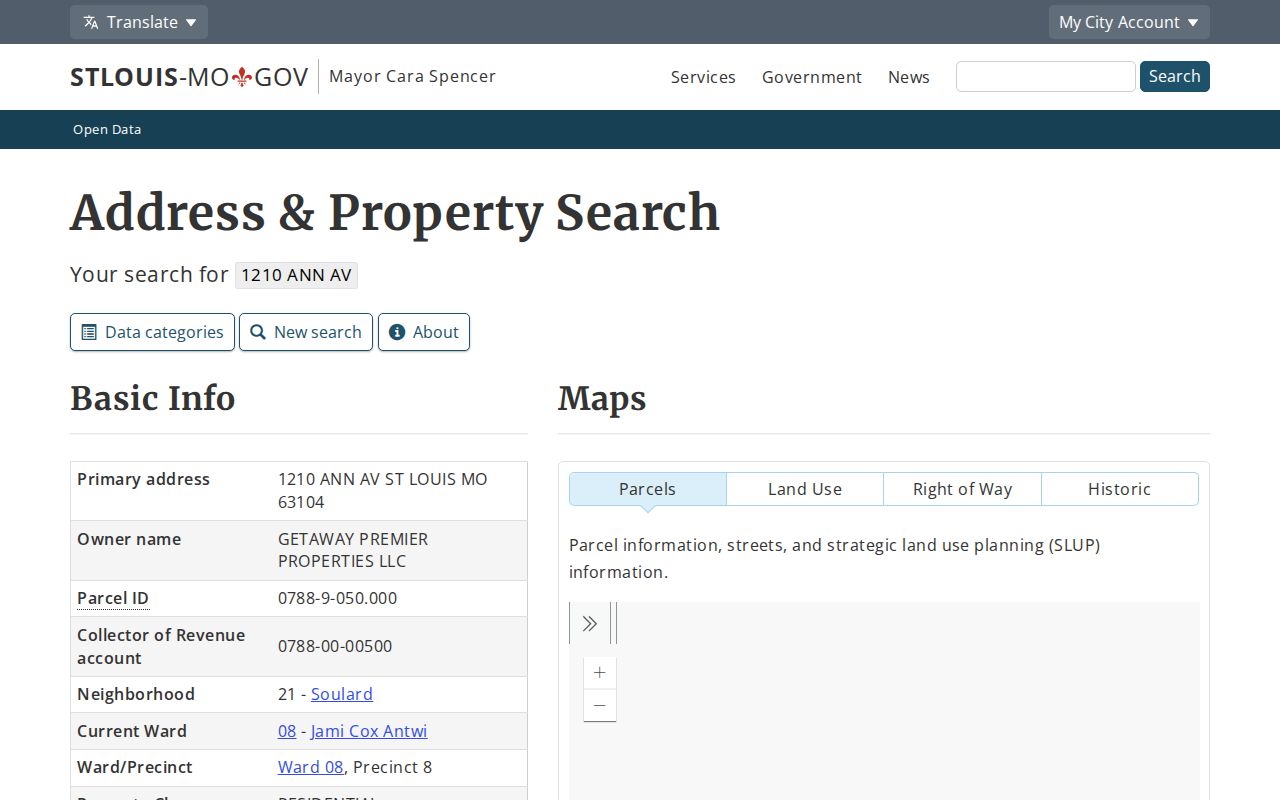
The sample shows why an address-keyed parcel result is a useful lead, while still requiring a deed or other source to confirm what a field means. Other Missouri assessors may use different fields and search options.
Browse Missouri Streets on GIS
No official parcel viewer covers every Missouri county. County and city systems may let a reader search by address, owner, or parcel, but the available fields differ. Kansas City’s official parcel workflow uses address search or map pan and zoom, a selectable parcel, a Parcel Data table, and a Layers tab for zoning and floodplain. Other layers may show roads, wards, districts, schools, neighborhoods, or historic rights of way.
For a street directory search, open the target parcel and inspect the next parcels along the frontage and side boundary. Use the parcel number or linked property page to verify what the map identifies. A layer that shows an address point does not guarantee a name field, and a viewer without a select or identify tool cannot promise a radius list. Missouri has no state parcel map that serves as a complete private-owner search.
- Parcel
- A mapped land unit identified by a local assessor or GIS system.
- Situs address
- The street location assigned to the property; it may differ from the owner’s mailing address.
- Plat
- A map that lays out lots, blocks, streets, and other parcel boundaries.
- Identify tool
- A map control that opens attributes for a selected parcel or feature, when the local viewer provides it.
When the viewer has no owner link, record the parcel ID and move to the assessor or recorder. Do not describe a Missouri map as a person search when it only draws parcel lines.
When Missouri Street Numbers Shift
An address may fail because a street name, house number, subdivision label, or local boundary changed. St. Louis City separated from St. Louis County in 1876, so its parcel and deed trail goes through city offices. The city publishes procedures for naming or renaming public streets, and an honorary name may sit alongside the current street name. The St. Louis Public Library’s St. Louis Room guide lists Building Department house-numbering certificates, maps, and Haines Criss-Cross directories, which can help connect older numbers to later ones.
For unincorporated roads, county and 911 or GIS offices may hold address-assignment history. Ask the office responsible for the address rather than guessing that a city record applies. If a historic deed names a parent county, township, land district, or old post-office name, use the jurisdiction at the document date and then look for successor records.
A legal description and plat can be more stable than a street label. A parcel may retain the same lot and block even when its mailing form changes, but each transfer still needs a matching land description before it is treated as the same place.
Missouri Records Searchable by Street
Address-keyed records answer different questions. An assessor describes a parcel and its tax account; a recorder documents legal transfers; GIS shows land shape and nearby features. Permits may name an owner, applicant, occupant, or contractor, while voter information is governed by separate limits. A street directory should keep those roles distinct.
| Missouri record source | What it can show | Access route |
|---|---|---|
| Assessor or collector | Owner, mailing address, parcel, legal description, value, tax class, and account fields | County or city portal; office or records request if online fields are limited |
| GIS parcel viewer | Lot lines, roads, zoning, districts, and sometimes owner or neighborhood links | Local map; available layers vary by county |
| Recorder of Deeds | Grantor, grantee, instrument type, record date, placement, and legal description | Online index where available, office terminal, mail, or custodian request |
| Plats and legal descriptions | Subdivision, lot, block, easement, or metes-and-bounds identity | Recorder, assessor links, county files, or State Archives microfilm |
| Permits and code records | Project dates and listed owners, applicants, occupants, or contractors | Address or parcel search where published; older records by request |
| Voter extracts | Limited voter fields tied to statutory geographic units | Local election authority request; public lookup is for self-checking |
| Criss-cross directories | Historical name or telephone entries associated with an address | Library or local-history collection for the relevant year |
The parcel ID is often the bridge from the assessor to a map, deed, tax account, or permit. A street name alone may not be indexed in the recorder’s land records, so preserve both the address and the legal description when requesting a search.
Follow Missouri Deed Indexes
A recorder index connects named parties to a recorded document. The St. Louis City direct search offers a free land-record index; document images and copies use a paid service or office channels. Ask the relevant Recorder of Deeds whether its public terminal reaches older books and how mail copies are handled.
The same direct search is linked in the statewide-lookups panel; its party index can be used before requesting an image or certified copy.
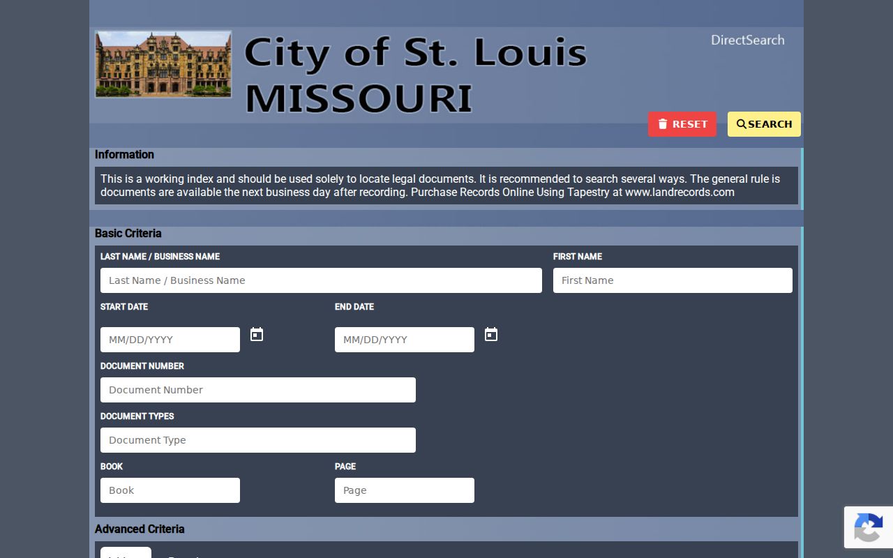
The index is a document-finding step. Check the record placement and use the office’s copy route when an image or certified record is needed.
Missouri Deed Records Have Cutoffs
The St. Louis City example is not a statewide cutoff. In Boone County, the Recorder of Deeds search covers real-estate documents from 1965 to the present, while handwritten index images cover 1821 to 1965. Pre-1965 document images require a subscription. Its page explains separate grantor and grantee indexes.
Boone County’s recorder page explains its current name search and historical index screens.
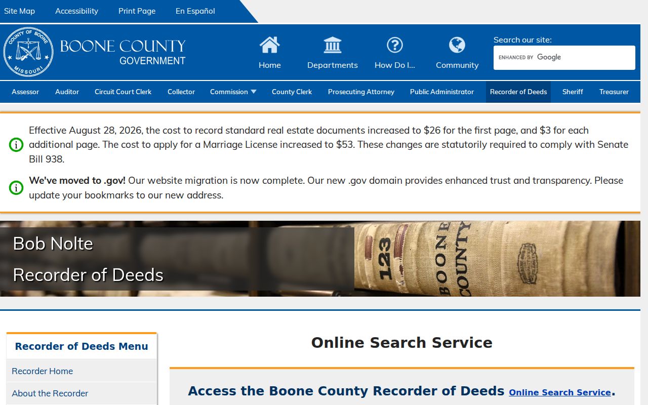
That image illustrates a local index. Do not carry Boone’s year ranges or subscription rules over to another Missouri recorder.
Start with the present grantee, find the purchase deed, then follow the seller backward as a prior grantee. If an online index stops, use the recorder counter or terminal, ask about mail copies, and check the State Archives county microfilm map. The Archives holds more than 72,000 reels, with series and year depth varying by county. Its county records are browsed by series and jurisdiction, not as a universal current-person name index.
Missouri Permits by Street Address
Permit records can add a date and work description to an address trail. St. Louis City offers a building-permit search by address or parcel, with links from its address result. A sample parcel record showed permits with an owner name, issue date, and description. The listed owner may be an organization or agent, and a permit does not establish who lived at the address.
The visible sample inventory included a parcel and collector account, neighborhood and ward fields, and permit entries spanning multiple project dates. The page linked thirteen permit items for the sample address. For a street record, note the address or parcel match, issue date, description, and the role attached to each name.
- Use a permit date to place a repair or project in time.
- Keep owner, applicant, occupant, and contractor labels as shown.
- Check the parcel number against the assessor before pairing a permit with a deed.
Other Missouri municipalities may keep permit data in separate systems or files. When no search page exists, ask the city department that issued the permit or make a focused records request.
Missouri Voter Fields by Street
Missouri voter records are maintained through 116 local election jurisdictions, including the 114 counties and St. Louis City. The Secretary of State’s Voter Information Lookup asks the voter to match the registered first and last name, date of birth, last four Social Security digits, and county. It returns that voter’s registration and polling information; it is not a name browser for everyone on a street. The live self-check is linked in the statewide-lookups panel.
RSMo 115.157 describes limited electronic or printed public fields, including a voter’s name, year of birth, address, and geographic assignment. Some election-specific files may be furnished for a fee by township, ward, or precinct. RSMo 115.158 restricts commercial use. Neither provision creates a public web roster of all Missouri residents or all voters at a street address.
For a lawful records request, identify the local authority through the Secretary of State election-authority directory. Specify the jurisdiction, election or geographic unit, fields, format, and delivery method, then ask the custodian about fees and use certification. Protected addresses remain closed. If an address search fails, the local authority can explain whether an older poll book or register survives; the research found no statewide historic name index.
Missouri Historical Street Directories
Reverse directories can connect a past address with an old name or telephone entry, but they describe a particular edition and area. The St. Louis Room guide lists Haines Criss-Cross directories, old maps, telephone books, yearbooks, and house-numbering certificates. It also identifies microfilmed city directories and older newspapers in the library’s genealogy collections.
Use a directory year that fits the address and keep the entry’s original spelling. A printed book can have publication lag, uneven coverage, and omissions; a name at an address does not establish a whole household. The historical shelves and how to read them are described on the Missouri city directory page.
Insider tip: If an address does not match an older entry, check house-numbering certificates and the parcel’s legal description before rejecting the lead. The number or name may have changed while the lot stayed the same.
Missouri ZIP and Jurisdiction Checks
A postal city is a delivery label, not proof of the parcel’s governing municipality or county. Missouri ZIPs can cross legal boundaries, while PO Box-only and unique ZIPs may not describe residential blocks. Verify a delivery address with the USPS ZIP Code Lookup, then use the assessor or county GIS to identify the legal jurisdiction for a deed, permit, or records request. The Missouri ZIP Directory links the postal lookup and explains the boundary limits.
A postal ZIP can narrow a delivery address but cannot replace the parcel and local-office check. A ZIP may also differ from a city ward, school district, county tax jurisdiction, or voter precinct. Choose the office that governs the parcel before asking for a street record.
Myth check: one ZIP does not equal one city, county, school boundary, or voter precinct. Resolve the property’s legal jurisdiction from a local source before treating two records as a match.
Record a Missouri Street Search
Keep a short research sheet so another reader can follow the same record trail. Note the exact URL, access date, jurisdiction, parcel ID, document placement, and which address label appears in each source. Preserve source wording when the record says “owner,” “mailing address,” “applicant,” or “occupant”; do not turn those labels into a claim about current residents.
If an online portal is missing or ends before the period you need, contact the local assessor, recorder, or permit custodian; ask about an in-person public terminal; request copies by mail if offered; and search State Archives microfilm or library holdings for historical material. Under RSMo 610.023, a custodian must act as soon as possible and by the end of the third business day unless reasonable cause supports delay. A written request should identify the record and likely custodian.
A record may be absent because it falls outside the portal’s dates, belongs to another jurisdiction, is indexed by party rather than street, or survives only on paper or film. Record that reason instead of treating silence as proof.
Limits of a Missouri Street Directory
Missouri records identify parcels, recorded transfers, listed voters, and dated directory entries. They do not create a complete live roll of everyone at an address. Tax fields describe the account, not every person at the property. A permit applicant may act for someone else. Court and voter records can be restricted, and driver information is not an open address source. Treat a missing result as a limit of that source, not proof that a person or event does not exist.
Missouri’s Safe at Home program allows eligible participants to use a substitute address in new government and court records. It does not erase older records, and an apparent substitute address must not be used to infer a protected location. Leave unnecessary identifying details out of any research note or public summary.
Lawful personal use. Use a street directory search for record verification, family history, or civic research. Do not follow, threaten, expose, or harass anyone, and do not try to identify a protected address.